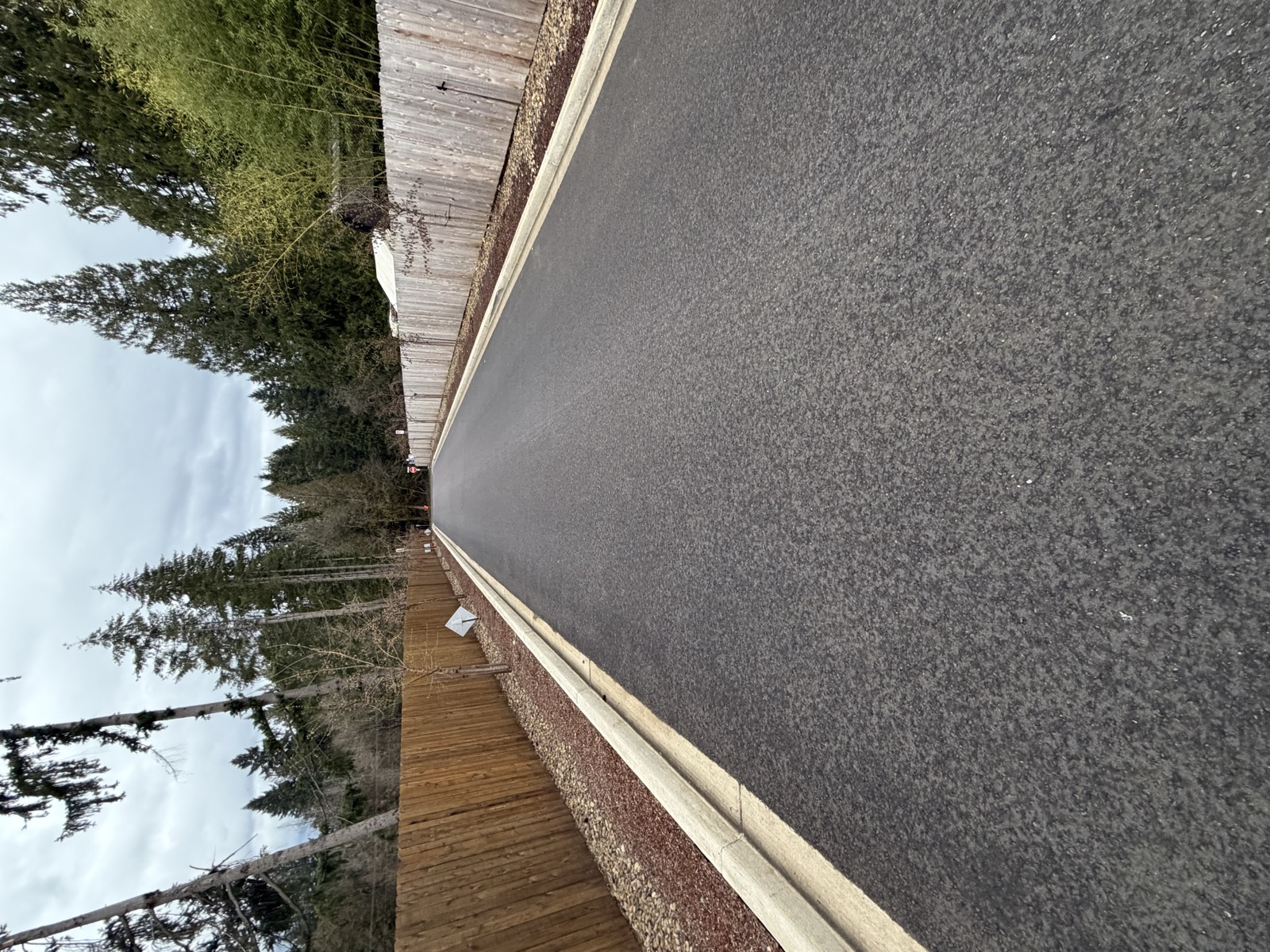
Salmon Creek Reserve — 72 new homes, families with children, and this is the road they walk, bike, and drive on every day. No sidewalks, no lights, no shoulders. This is the standard Clark County has set for our community.
Five development projects totaling 300+ homes have been approved on a road never designed for this level of traffic. The roads have no sidewalks, no shoulders, no bike lanes, and no secondary emergency access. This is not an isolated case — it is a pattern of how Clark County manages development.
We are not opposed to growth. We are asking Clark County to do its job: responsible development with safe infrastructure.
Cumulative impact of all five development projects on NE 174th Street
Clark County already has every traffic study it needs. Seven independent traffic impact studies — commissioned by seven different developers between 2023 and 2025 — all document the same failures on the same roads and intersections. A community analysis of those studies is compiled at 179gridlock.com. We are not asking for another study. We are asking Clark County to read the studies in its own files, acknowledge what they show, and stop approving development that the existing data already proves the roads cannot safely support.
“I am asking the Council to preserve the Mill Creek Overlay District (CCC 40.250.060) and its current standards, including the 9,000 sq ft minimum lot size (Standard C.3) and the requirement for additional public road access before new development is approved (Standard C.2). This overlay was created in 2009 through two years of community engagement specifically because the area has environmental constraints and only one road in and out. The proposed upzoning to R1-7.5 would increase allowable density by 4.5 times on infrastructure the county itself recognized as inadequate in 2009. The overlay should not be weakened or bypassed through the Comprehensive Plan update.”
We are not opposed to growth. The real ask is simple: we are asking Clark County to do its job — to pursue responsible development with a genuine focus on community access, transportation safety, sidewalks, bike lanes, and adequate road infrastructure, while also protecting and preserving the environmentally sensitive areas that the county itself identified when it created the Mill Creek Overlay District. The county has the code, the authority, and the obligation. We are asking it to use them.
Data from seven independent traffic impact studies (2023–2025). All projections assume planned infrastructure improvements — interchange reconstruction, roundabouts, road widening — are completed. They are not. Most are still in design phase (2029–2031).
Sources: Three Creeks East TIS (Jun 2025), Four Creeks North TIS (Apr 2025), NE 174th St TIS (Dec 2025), Kozy Manor Estates TIS (Feb 2025), Towhee Creek TIS (Dec 2025), Ridgefield MS TIS (Jun 2024), Mt Vista Logistics TIS (Jan 2023). Analysis compiled by Heidi Owens for the Four Creeks Neighborhood Association, March 2026.
Every one of these traffic studies was submitted to Clark County as part of the development approval process. The county has the data. Seven independent consulting firms, hired by seven different applicants, all document the same failures on the same roads and intersections. The county approved the projects anyway.
Road improvement deferrals are granted project by project. Cumulative impacts are never assessed. The result is a corridor where every major intersection is at or past the breaking point — on paper, before the infrastructure improvements that are still years away from construction.
This also raises a question of state oversight. Under Washington’s Growth Management Act (RCW 36.70A) and subdivision statute (RCW 58.17.110), counties are required to ensure adequate infrastructure and safe walking conditions before approving development. Where is the accountability when a county approves density that its own traffic studies show the roads cannot handle?
Salmon Creek Reserve — 72 new homes, families with children, and this is the road they walk, bike, and drive on every day. No sidewalks, no lights, no shoulders. This is the standard Clark County has set for our community.
Six fundamental issues with how development is proceeding
NE 174th Street is less than 20 feet wide with no sidewalks, shoulders, bike lanes, or lighting — serving 300+ approved homes on a road that should be 32–36 ft. Seven independent traffic studies across the NE 179th corridor confirm the same pattern: 17+ road segments over capacity, 6 intersections at LOS F, and every study reaches the same conclusion. These failures are projected even after crediting planned infrastructure improvements as complete.
County code requires secondary emergency access when more than 100 lots use a single access road. NE 174th Street has 302+ approved lots with no secondary access — and the requirement has never been enforced.
This is the same pattern that killed people in Paradise, California (85 dead), Oakland Hills (25 dead), Gatlinburg, Tennessee (14 dead), and other communities across the country. In every case, neighborhoods were approved for density that exceeded the road’s evacuation capacity. When disaster struck, residents died in gridlocked traffic on roads that were never built for that many people. NE 174th Street has the same single-access vulnerability — with 302+ homes funneling onto a road less than 20 feet wide.
Each development is evaluated in isolation. Cumulative road impacts are never assessed. Road improvement deferrals are granted project by project. The result: 300+ homes approved on infrastructure exceeding its original design.